|
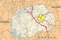
The road network in Municipality of Stip has a total length of 377,4 km from which 47,0 km (12,45%) are highway roads, 22,4km (5,94%) are regional roads and the remained 308,0 km (81,61%) are local roads. From the total road network of Municipality Stip 230, 4 km formed street network in the urban settlements. The remained 147, 0 km go to the roads which connect the settlements within the municipality. In Stip you can come through the highway M-5 (Stip – Kochani – Delchevo) which has a connection with the divided highway E-75 (Skopje – Gevgelija) thanks to the road Stip – Veles. There are the regional roads P – 601 (Stip – Mountain Plachkovica) and P – 526 which passes through the city itself and connects on the highway M-5. In plan is building a new road direction (Stip – Miladinovci) which will shorten the travelling to the capital Skopje. has a total length of 377,4 km from which 47,0 km (12,45%) are highway roads, 22,4km (5,94%) are regional roads and the remained 308,0 km (81,61%) are local roads. From the total road network of Municipality Stip 230, 4 km formed street network in the urban settlements. The remained 147, 0 km go to the roads which connect the settlements within the municipality. In Stip you can come through the highway M-5 (Stip – Kochani – Delchevo) which has a connection with the divided highway E-75 (Skopje – Gevgelija) thanks to the road Stip – Veles. There are the regional roads P – 601 (Stip – Mountain Plachkovica) and P – 526 which passes through the city itself and connects on the highway M-5. In plan is building a new road direction (Stip – Miladinovci) which will shorten the travelling to the capital Skopje.
|


